First off, let me say that nothing on this site is trying to sell you anything. There are no links to Amazon - nothing. The information here is my opinion - nothing more - nothing less. This article was last updated in April 2024.
I initially created this article because I owned a Lowrance 2000c GPS and one day, out of the blue, Lowrance decided to stop selling and more importantly, stop supporting their aviation GPS units. They handled the situation totally wrong! Their decision to completely abandon the aviation community so abruptly was totally unacceptable and I will never have one of their products again - not for my boat, not for anything!
Now, for a replacement, here are my thoughts. This is a list of portable aviation GPS units and software solutions that I put together as a quick reference guide. It's not a complete comparison by any means. It is meant to let you know what is available and where to get more information about them. Please note that I place a very high emphasis on being American Made as this country is in dire need of jobs right now - I hope you'll take that into consideration when making your next purchase.
1. Garmin is a great company and the leader in aviation avionics but they tend to be pricey. I must admit that they've started seeing the light it appears as their latest model of portable GPS is much cheaper than their previous models.
2. AvMap EKP V is a portable aeronautical GPS with a 7 inch display and sunlight-viewable LCD. It's a foreign company (Italy) and updates are a pain to accomplish (by E-mail / web and ZIP files). At the price of this line of GPS units, I'd opt for a Garmin instead at $1800 plus. At least then I wouldn't have to worry about getting caught up in another "Lowrance" situation.
3. Anywhere Map was a software-only solution. It appears that they've discontinued their model.
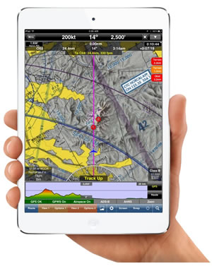
4. The iFly EFB by Adventure Pilot™ offers a 7 inch touch screen display, low cost annual aviation updates, and many unique features for a fairly reasonable price. Standard price includes STAR, Approach and Departure and other FAA charts (never buy Sectionals again!), airport diagrams, big buttons that fade out when not needed, zoom levels from 2 to 100 NM per inch, multi leg flight plans, and much, much more. Connect the iFly EFB to an ADS-B (In) receiver and you'll get free weather maps and an aircraft avoidance system - all displayed on the iFly EFB (or your pad)! In addition to their hardware and software solution, they also offer a software-only solution for your own pad. See their site.
5. Low cost phone / tablet solutions: Are you looking for a Android/Apple phone or iPad/Android Tablet solution? Try WingX Pro (see note, below) for under $100.
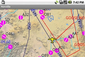
6. Finally, if you have an Android Tablet (or even a android phone), you really should give Avare (pronounced Av Air) a try. Avare is a aviation moving map GPS system that also supports ADSB and AHRS (no kidding). It is TOTALLY free, wrote by pilots for pilots and it is evolving really fast. Avare's basic features include online or offline air field info, approach plates, and GPS moving map on all FAA VFR Sectionals, WACs, and TACs, plus IFR Low charts and airport diagrams. You can also manually browse all charts and all other materials even without cell service or GPS. Current FAA weather METARs, TAFs, and TFRs are provided too. You can get Avare from the Play Store on your android phone or tablet. There is no support currently for Apple products.
Before we look at the hardware and software, it's important to know about four terms thrown around today; WAAS, A-GPS, ADS-B, AHRS:
What is WAAS: Wide Area Augmentation System (WAAS) is an air navigation aid developed by the FAA to enhance GPS. WAAS improves its accuracy, integrity, and availability. It is important to me and should be important to all pilots, that their GPS be WAAS enabled. Not all GPS systems that claim to be intended for aviation are WAAS enabled so you might want to ask that question before you make the purchase. If you're not 'up' on WAAS and why it is important, check out this wiki on the subject. For iPad/iPhone users, you really might want to ask this question before buying the iPad! Certain iPad models don't even have any GPS at all and when they do have a GPS, they are not ever WAAS enabled. iPad users will want to purchase an external WAAS enable GPS.
What is 'A-GPS'? A-GPS means 'Assisted GPS' and is usually typed as 'A-GPS' or 'aGPS'. It is a GPS system that's mainly used on Pads and cell phones to quickly get a GPS fix using the internet. Normal GPS uses radio signals from satellites where A-GPS systems initially use the internet to arrive at a fix quickly then they change over to normal GPS after the cell phone / pad has had time to get it's normal fix. Having a A-GPS system gives the pilot NO features or benefit at all but they still work as a normal GPS. Under some circumstances, A-GPS can actually cost you money by using your cell service unnecessarily. A WAAS enable GPS is what pilots need, not A-GPS.
What is ADS-B? Automatic Dependent Surveillance - Broadcast (ADS-B) is a reasonably new technology currently being used by the FAA in the US that allows pilots in the cockpit and ATC to 'see' aircraft traffic with precision. ADS-B also broadcasts real-time weather information to pilots. This information significantly increases flight safety. The best 'feature' is that ADS-B is free of charge. To take advantage of this system, you will need a GPS capable of using ADS-B data and you will need an ADS-B transceiver that broadcasts your info and a receiver that receives other people's location information and live weather data. Currently, ADS-B 'out' was mandated nationwide by January 1, 2020 as part of the NextGen national airspace strategy for upgrading and enhancing the aviation infrastructure. ADS-B 'out' is where your aircraft broadcasts its position to other aircraft. ADS-B 'in' is the instrument in your aircraft that shows where other traffic is located. See the wiki for more info.
What is AHRS? Attitude and Heading Reference System (AHRS) is a system of sensors on three axes that provide heading, attitude and yaw information for aircraft. AHRS is designed to replace traditional mechanical gyroscopic flight instruments and provide superior reliability and accuracy. AHRS consist of either solid-state or microelectromechanical systems (MEMS) gyroscopes, accelerometers and magnetometers on all three axes. AHRS is usually part of what most people now call a 'glass cockpit'.
Here I attempt to compare some key aviation GPS units as well as software-only aviation navigation solutions: