| Airfield: |
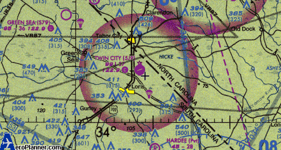
TWIN CITY, USA (SOUTH CAROLINA) |
| Coordinates: |
34° 5' 0.8300" N 78° 51' 0.3700" W (34.08356389, -78.85010278) - Estimated |
| Elevation: |
99' MSL - Surveyed |
| Variation: |
08W (2000) |
| Location: |
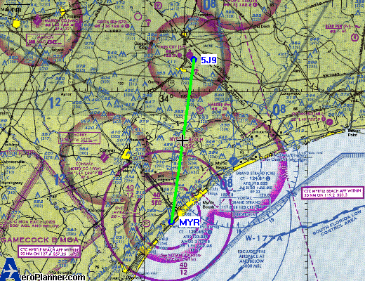
3 miles NE of LORIS, SC |
| Sectional: |
CHARLOTTE |
The Facility
| Use: |
Open to the public |
| ARTCC: |
JACKSONVILLE |
| FSS: |
ANDERSON (1-800-WX-BRIEF) |
| NOTAMs Facility: |
AND (with NOTAM-D service) |
| Owner (Public): |
HORRY COUNTY
PO BOX 1236
CONWAY, SC 29526
843-248-1201 |
Manager: |
BOB KEMP
100 JETPORT ROAD
MYRTLE BEACH, SC 29577
843-448-1580 |
|
| Landing Fee: |
No |
| Control Tower: |
No |
| Attendance: |
| Season |
Days |
Hours |
| UNATNDD |
|
| Lighting Schedule: |
DUSK-DAWN |
| Beacon: |
Clear-Green (Lighted Land Airport) |
| Segmented Circle: |
Yes |
NEARBY AIRPORTS
| Facility |
Distance |
Course |
Coordinates |
| TURBEVILLE [NC78] |
8.6 nm |
324° |
34° 12' 1" N 78° 57' 1" W |
| HARDEE [SC21] |
9.1 nm |
170° |
33° 56' 0" N 78° 49' 1" W |
| GREEN SEA [S79] |
10.2 nm |
306° |
34° 11' 1" N 79° 1' 0" W |
| STRICKLAND FIELD [89NC] |
13 nm |
320° |
34° 15' 1" N 79° 1' 1" W |
| COLUMBUS CO MUNI [CPC] |
13.3 nm |
34° |
34° 16' 0" N 78° 42' 0" W |
| GRAND STRAND [CRE] |
18.2 nm |
159° |
33° 48' 0" N 78° 43' 1" W |
| MYNATT FIELD [53NC] |
20.1 nm |
328° |
34° 22' 0" N 79° 4' 0" W |
| CONWAY HORRY CO [HYW] |
20.8 nm |
220° |
33° 49' 0" N 79° 7' 1" W |
| OCEAN ISLE [60J] |
23.5 nm |
118° |
33° 54' 0" N 78° 26' 0" W |
| MARION CO [MAO] |
24.6 nm |
282° |
34° 10' 0" N 79° 20' 0" W |
NATIONAL DATABASES
This facility is identified by the FAA as location 5J9.
The FAA also uses site number 22399.*A.
NGA's DAFIF uses US28841.
The FAA data used in this report is effective January 20, 2005 through March 17, 2005.
The DAFIF data used in this report is effective February 17, 2005 through March 17, 2005.
NEARBY NAVAIDS
| CAMP |
CPC |
NDB |
227 K |
|
13.2 nm |
31° |
34° 16' 19" N 78° 42' 50" W |
| CALAB |
CR |
NDB |
267 K |
|
16.2 nm |
137° |
33° 53' 7" N 78° 37' 48" W |
| GRAND STRAND |
CRE |
VORTAC |
117.60 M |
123X |
17.3 nm |
159° |
33° 48' 50" N 78° 43' 28" W |
| HORRY |
HYW |
NDB |
370 K |
|
20.5 nm |
222° |
33° 49' 46" N 79° 7' 26" W |
| MARION |
MAO |
NDB |
388 K |
|
24.8 nm |
284° |
34° 11' 7" N 79° 19' 59" W |
| JIGEL |
JB |
NDB |
384 K |
|
31.2 nm |
333° |
34° 32' 46" N 79° 8' 18" W |
| ELIZABETHTOWN |
TGQ |
NDB |
398 K |
|
31.4 nm |
32° |
34° 31' 43" N 78° 30' 57" W |
| LUMBERTON |
LBT |
VOR |
110.00 M |
|
33.2 nm |
342° |
34° 36' 39" N 79° 3' 17" W |
| ROBESON |
RSY |
NDB |
359 K |
|
33.4 nm |
342° |
34° 36' 49" N 79° 3' 35" W |
| DILLON |
DLC |
NDB |
274 K |
|
33.9 nm |
311° |
34° 27' 0" N 79° 22' 8" W |
|
| Note: "Course"(degrees true) and "Distance" are both measured from the Airfield Reference Point.
|
RUNWAYS
Runway 08/26
3,694 x 60 ft
ASPHALT - Good Condition
Runway Lights Edge Intensity: LOW
| True Heading |
074° |
254° |
Right Hand
Traffic for Landing |
N |
N |
| Runway Markings |
Basic - Good Condition |
Basic - Good Condition |
| End Coordinates |
34° 5' 0" N 78° 52' 0" W |
34° 5' 0" N 78° 51' 0" W |
| Elevation |
99.2 ft |
99.3 ft |
Threshhold
Crossing Height |
|
34 ft |
| Visual Glide Path Angle |
|
3.50° |
| Displaced Threshold |
200 ft |
|
| Disp Thld Coordinates |
34° 5' 0" N 78° 52' 0" W |
|
| TDZ Elevation |
99 ft |
99 ft |
| GlideSlopeInd |
|
2-Box SAVASI on left Side of Runway |
| Controlling Object |
TREE
Slope: 15:1
32' above runway
669' from end of runway
102' right of runway
FAR Part 77: A(V)
|
TREE
Slope: 20:1
67' above runway
1594' from end of runway
218' left of runway
FAR Part 77: A(V)
|
|